Kirk Klausmeyer

Director of Data Science
Technology
[email protected]
In The Nature Conservancy’s California Chapter, Kirk applies drones, big data, and other emerging technologies to address pressing environmental challenges in California. Kirk's recent work includes a project to estimate natural flows in rivers using machine learning , a web-app to monitor groundwater dependent ecosystems using remote sensing, and an annual survey to map kelp forests using drones. Kirk has authored 15 publications in peer-reviewed journals during his time at the Conservancy.
Before he joined the Conservancy, Kirk worked as an independent developer and an environmental consultant. He holds a B.A. in environmental studies and economics from Dartmouth College and M.A. in planning from the University of California, Berkeley.
What Kirk is working on now:
I am currently analyzing stream flow data to determine the best places to restore natural flows in California's rivers. I am leading an effort to develop a webmap to highlight locations where rivers and groundwater interact to provide cool consistent water to freshwater ecosystems. I am also using remote sensing and drone data to track changes in kelp forests over time.
Select products
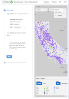
2025 | Freshwater | Planning | Technology | Microsite
Functional Flows Calculator
Kirk Klausmeyer, Bronwen Stanford, Nathan Enerson, Steven Sonvisen, Falk Schuetzenmeister, and Jam Hamidi
To protect water for nature, we first need to understand current flow conditions in our rivers, and how that flow is altered from natural conditions. Under the California Environmental Flows Framework…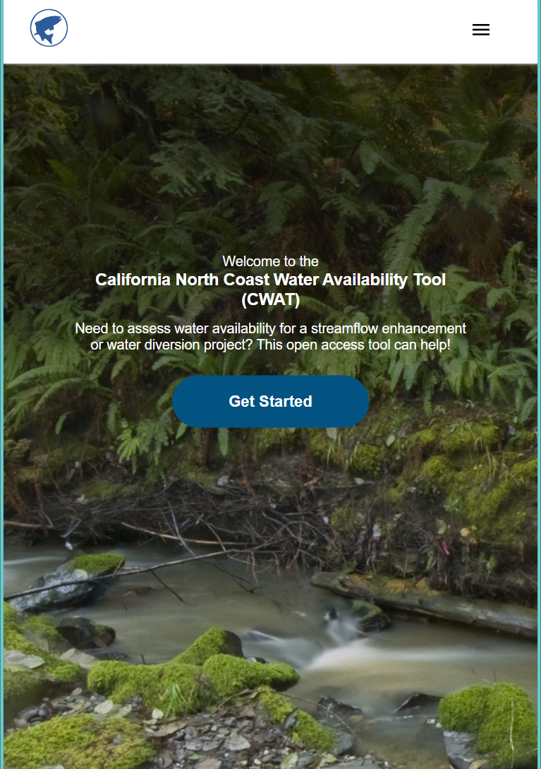
2025 | Freshwater | Planning | Technology | Microsite
California North Coast Water Availability Tool
Jennifer Carah, Ben Kerr, Mia van Docto, Anders Farr, Kirk Klausmeyer, Steven Sonvisen, Siena Testa, and Jam Hamidi
Water is essential for California’s people, economy, and environment, yet water availability for people and nature is not well understood. This tool efficiently assesses water availability in…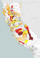
2023 | Freshwater | Microsite
Drought Flows Monitor
Julie Zimmerman, Jennifer Carah, Kirk Klausmeyer, Gabe Rossi, Mia Van Docto, Jeanette Howard, Charlie Schneider, Matt Clifford, Monty Schmitt
Drought conditions are occurring with more frequency, greater severity, and longer duration under climate change. Human water use compounds the effects of drought, further stressing California’s…
2022 | Marine | Technology | Science | Publications & Reports
Using unoccupied aerial vehicles to map and monitor changes in emergent kelp canopy after an ecological regime shift
Vienna R. Saccomanno, Tom Bell, Camille Pawlak, Charlotte K. Stanley, Katherine C. Cavanaugh, Rietta Hohman, Kirk R. Klausmeyer, Kyle Cavanaugh, Abby Nickels, Waz Hewerdine, Corey Garza, Gary Fleener, Mary Gleason
Kelp forests are complex underwater habitats that provide valuable services for both people and nature. Despite their importance, increasingly severe stressors have resulted in declines in kelp…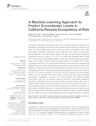
2022 | Freshwater | Planning | Science | Publications & Reports
A Machine Learning Approach to Predict Groundwater Levels in California Reveals Ecosystems at Risk
Melissa M. Rohde, Tanushree Biswas, Ian W. Housman, Leah S. Campbell, Kirk R. Klausmeyer, Jeanette Howard
Groundwater dependent ecosystems (GDEs) are increasingly threatened worldwide, but the shallow groundwater resources that they are reliant upon are seldom monitored. In this study, the researchers…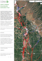
2022 | Freshwater | Planning | Science | Maps & Webmaps
SAGE: Shallow Groundwater Estimation Tool
Melissa M. Rohde, Tanushree Biswas, Ian W. Housman, Leah S. Campbell, Kirk R. Klausmeyer, Jeanette Howard
Groundwater dependent ecosystems (GDEs) are critical habitats throughout California that rely on shallow groundwater. Unfortunately, only a small subset of wells provide monitoring data for shallow…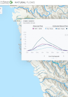
2021 | Freshwater | Science | Maps & Webmaps
California Natural Flows Webapp
Julie K.H. Zimmerman, Daren M. Carlisle, Jason T. May, Kirk R. Klausmeyer, Theodore E. Grantham, Larry R. Brown, Jeanette K. Howard, Nathaniel Rindlaub, Falk Schuetzenmeister
Water is essential for California’s people, economy, and environment. Centuries of water management through dams and diversion have altered the flows in many streams and rivers, which can harm…2021 | Freshwater | Planning | Maps & Webmaps
ICONS: Interconnected Surface Water in the Central Valley
This dataset categorizes the rivers and streams in the Central Valley on the likelihood that they are interconnected surface water (ISW) -- surface water hydraulically connected to groundwater. The…
2019 | Terrestrial | Technology | Science | Publications & Reports
Parched pines: a quantitative comparison of two multi-year droughts and associated mass mortalities of bishop pine (Pinus muricata) on Santa Cruz Island, California
Annalise Taylor, Tanushree Biswas, John M. Randall, Kirk Klausmeyer, Brian Cohen
In Western North America, droughts are expected to increase in frequency and intensity as the region’s climate changes. Over past decades, land managers on Santa Cruz Island, California…
2019 | Freshwater | Technology | Science | Maps & Webmaps
GDE Pulse: Monitoring Groundwater Dependent Ecosystems with Satellites
Kirk Klausmeyer, Falk Schuetzenmeister, Nathaniel Rindlaub, Tanushree Biswas, Melissa M. Rohde, Jeanette Howard
94,333 unique ecosystems depend on groundwater in California. GDE Pulse lets you see how they have changed over the last 30 years. Groundwater managers and environmental stakeholders often lack…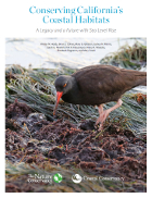
2018 | Freshwater | Terrestrial | Marine | Planning | Science | Publications & Reports
Conserving California's Coastal Habitats: A Legacy and a Future with Sea Level Rise
Walter N. Heady, Brian S. Cohen, Mary G. Gleason, Joshua N. Morris, Sarah G. Newkirk, Kirk R. Klausmeyer, Hilary R. Walecka, Elizabeth Gagneron
Sea level rise presents a new challenge to coastal conservation. The authors quantified and mapped the vulnerability of habitats, imperiled species, and conservation lands to sea level rise throughout…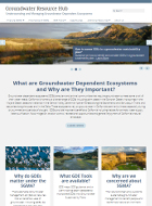
2018 | Freshwater | Science | Microsite
Groundwater Resource Hub
Sandi Matsumoto, Gregg Werner, Melissa Rohde, Kirk Klausmeyer
Groundwater dependent ecosystems (GDEs) are plant and animal communities that require groundwater to meet some or all of their water needs. GDEs provide important benefits to California including…
2017 | Freshwater | Science | Publications & Reports
Patterns and magnitude of flow alteration in California, USA
Julie K H Zimmerman, Daren M. Carlisle, Jason T. May, Kirk R. Klausmeyer, Theodore E. Grantham, Larry R. Brown, Jeanette K. Howard
The importance of the natural flow regime to stream and river health has received growing attention in recent years. Understanding natural flows and patterns of flow alteration is an important first…
2017 | Marine | Technology | Science | Video
Aquaculture by Design, Tomales Bay
Serena Lomonico, Robert Jones, Torrey Johnson, Sarah Newkirk, Sarah Lummis, Kirk Klausmeyer, John Finger, Terry Sawyer, Richard James
Aquaculture is becoming an increasingly important global food source. With this growth comes urgent, unanswered questions about the interactions of aquaculture operations—both positive and…
2017 | Freshwater | Planning | Publications & Reports
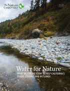
Water for nature: What we can do today to help California’s rivers, streams and wetlands
Burns, C.E., A. Hoss, N. Smith, K. Klausmeyer, K. Fesenmeyer, A. Campbell, J. Carah, E. Forsburg, S. Heard, J.K. Howard, L. Hulette, S. Liu, P. Spraycar, B. Stranko, G. Werner, D. Wordham
This report identifies a set of strategies that will have the greatest impact on environmental flows, and to provide a resource for conservation organizations, resource agencies, and other…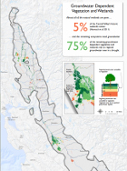
2016 | Freshwater | Maps & Webmaps
How and Where Nature Uses Groundwater
Kirk Klausmeyer, Jeanette Howard, Sandi Matsumoto, Sally Liu, Melissa Rohde
Groundwater is essential to the health and viability of plants, animals and ecosystems. Many tree species, like willows and cottonwoods, rely on groundwater to survive seasonal and annual dry spells.…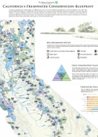
2015 | Freshwater | Planning | Maps & Webmaps
California’s Freshwater Conservation Blueprint map
The transformation of California into one of the most productive agricultural and urban landscapes in the world and a growing population have put unprecedented pressure on freshwater habitats,…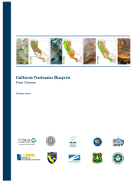
2015 | Freshwater | Science | Publications & Reports
California Freshwater Blueprint: Phase I Overview
Jeanette K. Howard, Kirk R. Klausmeyer, Kurt A. Fesenmyer
California is one of the most productive agricultural and urban landscapes in the world with a growing population. These pressures have reduced aquatic and wetland habitats to a small fraction of…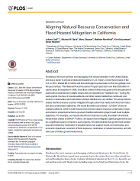
2015 | Freshwater | Marine | Publications & Reports
Aligning Natural Resource Conservation and Flood Hazard Mitigation in California
Juliano Calil, Michael W. Beck, Mary Gleason, Matthew Merrifield, Kirk Klausmeyer, Sarah Newkirk
The U.S. National Flood Insurance Program has paid out more than $38 billion in claims since its inception in 1968, more than a third of which has gone to the 1% of policies that experienced multiple,…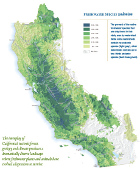
2015 | Freshwater | Planning | Data
California Freshwater Species Database v2
Jeanette Howard, Kirk Klausmeyer, Kurt Fesenmyer
The California Freshwater Species Database is the first comprehensive geospatial database of California’s freshwater species compiled and standardized into single format from nearly 500 sources.…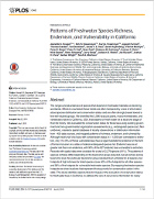
2015 | Freshwater | Planning | Science | Publications & Reports
Patterns of Freshwater Species Richness, Endemism, and Vulnerability in California
Jeanette K. Howard, Kirk R. Klausmeyer, Kurt A. Fesenmyer, Joseph Furnish, Thomas Gardali, Ted Grantham, Jacob V. E. Katz, Sarah Kupferberg, Patrick McIntyre, Peter B. Moyle, Peter R. Ode, Ryan Peek, Rebecca M. Quiñones, Andrew C. Rehn, Nick Santos, Steve Schoenig, Larry Serpa, Jackson D. Shedd, Joe Slusark, Joshua H. Viers, Amber Wright, Scott A. Morrison
The California Freshwater Species Database is the first comprehensive geospatial database of California’s freshwater species compiled and standardized into single format from nearly 500 sources.…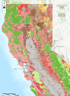
2014 | Terrestrial | Planning | Science | Maps & Webmaps
Actions Likely to Increase Plant and Animal Resilience to Climate Change
This webmap provides regional climate projections with information about topography, coastal proximity and level of habitat fragmentation to help land managers identify concrete conservation…
2013 | Terrestrial | Planning | Publications & Reports
Laying the Foundation: How Existing Conservation Areas Have Helped Prepare California for Climate Change
This study evaluated the existing network of conservation lands in California to determine the extent to which it includes landscape features that may be especially important for biodiversity…
2013 | Freshwater | Planning | Science | Publications & Reports
Below the Surface: California’s Freshwater Diversity
Jeanette Howard, Kirk Klausmeyer, Kurt Fesenmyer
Californians face profound decisions regarding the management of their state’s increasingly limited water supply. Critical for decision-making is information about the plants and animals that…
2012 | Terrestrial | Planning | Publications & Reports
Economic costs of achieving current conservation goals in the future as climate changes
M. Rebecca Shaw, Kirk Klausmeyer, D. Richard Cameron, Jason MacKenzie, Patrick Roehrdanz
Species will move around the landscape as the climate changes, presenting challenges for traditional conservation strategies like land acquisition. This paper models the cost and total land area that…
2012 | Freshwater | Publications & Reports
Where Does California’s Water Come From? Land conservation and the watersheds that supply California’s drinking water
Kirk Klausmeyer, Katie Fitzgerald
Key to protecting drinking water for all Californians is understanding the sources and health of the thier watersheds. This study maps California's surface drinking water sources, the watersheds…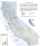
2012 | Freshwater | Maps & Webmaps
California's Flood Risk: Green Solutions for an Uncertain Future
Almost 9 million acres of California are at risk from flooding. These flood zones cover 16% of the state’s urban and suburban development, and 36% of the state’s land dedicated to…
2011 | Freshwater | Terrestrial | Marine | Planning | Science | Publications & Reports
The impact of climate change on California’s ecosystem services
Shaw, M.R., L. Pendleton, D.R. Cameron, B. Morris, D. Bachelet, K. Klausmeyer, J. MacKenzie, D.R. Conklin, G.N. Bratman, J. Lenihan, E. Haunreiter, C. Daly, P.R. Roehrdanz
As the climate warms, changes in ecosystems will impact human communities and livelihoods. This paper, together with a California Energy Commission Scenarios Report of the same name, explores the…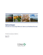
2011 | Freshwater | Marine | Planning | Publications & Reports
SalmonScape: Priorities for Conserving California’s Salmon and Steelhead Diversity
This report analyzed Chinook, coho salmon, and steelhead trout population and habitat data across California to identify a portfolio of places called the SalmonScape. SalmonScape identifies areas…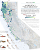
2011 | Freshwater | Marine | Planning | Maps & Webmaps
SalmonScape map
The Conservancy's SalmonScape is an analysis and map that analyzed and ranked the watersheds that support or contribute to salmon habitat in California based on where conservation efforts…
2011 | Terrestrial | Science | Publications & Reports
Landscape-scale indicators of biodiversity's vulnerability to climate change
Klausmeyer, K. R., M. R. Shaw, J.B. MacKenzie, D.R.Cameron
This analysis provides an approach for distilling complex climate and landscape data into actions land managers can take to help plants and animals adapt to a changing climate. Based on historical…
2011 | Terrestrial | Planning | Publications & Reports
Northern Sierra Partnership Climate Adaptation Assessment
Cameron, D., K. Klausmeyer, J. Mackenzie, G. Low, L. Provencher
Climate change will impact plants and animals across the state, and conservationists are often unaware of the best way to address this threat. While much of the land in the Northern Sierra is public…
2011 | Terrestrial | Publications & Reports
Planning for Adaptation to Climate Change: Methods and Lessons Learned from Mt. Hamilton, California
Kirk Klausmeyer, Dan Olstein, Terri Schulz, Robin Cox, Sasha Gennet, Jason MacKenzie
While the literature and guidance on traditional conservation planning methods is extensive, there are few case studies on methods for incorporating climate change into conservation planning efforts.…
2011 | Freshwater | Science | Publications & Reports
Identifying habitat conservation priorities and gaps for migratory shorebirds and waterfowl in California
Stralberg, D., D. Cameron, M. Reynolds, C. Hickey, K. Klausmeyer, S. Busby, L. Stenzel, W. Shuford, G. Page
This analysis provides the first comprehensive overview of the specific habitats used by 42 different migratory waterbird species throughout California. The authors reveal important gaps in…
2010 | Terrestrial | Planning | Publications & Reports
Mojave Desert Ecoregional Assessment
John M. Randall, Sophie S. Parker, James Moore, Brian Cohen, Laura Crane, Bill Christian, Dick Cameron, Jason B. Mackenzie, Kirk Klausmeyer, Scott Morrison
Regional conservation planning is critical to inform land and resource use decisions. The Mojave Desert Ecoregional Assessment represents an important advance in such planning, because of how its…
2009 | Terrestrial | Planning | Publications & Reports
Threats and biodiversity in the mediterranean biome
E.C. Underwood, J.H. Viers, K.R. Klausmeyer, R.L. Cox, M. R. Shaw
The mediterranean biome is one of the rarest terrestrial ecosystem types on Earth, restricted to only 2% of the world’s land surface. Encompassing portions of southern Australia, central Chile,…
2009 | Terrestrial | Planning | Publications & Reports
Expanding the global network of protected areas to save the imperiled mediterranean biome
Underwood, E.C., K.R. Klausmeyer, R.L. Cox, S.M. Busby, S.A. Morrison, M.R.Shaw
Mediterranean habitats are among the rarest on Earth. Characterized by warm dry summers and cool wet winters, they are restricted to only 2% of the Earth’s land surface–portions of…