Falk Schuetzenmeister
Software Engineer
Technology
[email protected]
In The Nature Conservancy’s California Chapter, Falk serves as a full stack developer supporting the Science and Conservation teams by building data solutions and web-based monitoring applications. He works with very diverse data such as remote sensing products, imagery from fishery monitoring cameras, environmental sensors and mobile devices. He advocates for a versatile IoT framework and is an educational resource for scientists scripting in Python, R and JavaScript for their research and cloud services. He hopes to unlock the potential of new technologies and open source approaches for conservation.
Prior to joining the Conservancy, Falk worked as a geospatial software developer and modeling specialist at the California Invasive Plant Council, at the University of California, Berkeley’s Geospatial Innovation Facility and as a fellow at the Berkeley Institute for Data Science. He holds a Ph.D. in sociology from Technische Universität Dresden where he studied the role of technology in global environmental science.
Select products
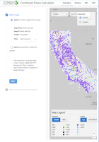
2025 | Freshwater | Planning | Technology | Microsite
Functional Flows Calculator
Kirk Klausmeyer, Bronwen Stanford, Nathan Enerson, Steven Sonvisen, Falk Schuetzenmeister, and Jam Hamidi
To protect water for nature, we first need to understand current flow conditions in our rivers, and how that flow is altered from natural conditions. Under the California Environmental Flows Framework…
2025 | Terrestrial | Technology | Publications & Reports
Real-time island biosecurity surveillance: evaluating a wireless camera network for AI-assisted early detection of invasive mammals on Santa Cruz Island, CA
Lara J. Brenner, Nathaniel Rindlaub, Juliana Matos, Scott Meyler, Sue Pollock, Falk Schuetzenmeister, Nick D. Holmes
Invasive mammals like rats pose a major threat to island ecosystems and endemic species. This study tests a wireless camera network on Santa Cruz Island that uses AI to detect nonnative mammals in…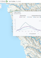
2021 | Freshwater | Science | Maps & Webmaps
California Natural Flows Webapp
Julie K.H. Zimmerman, Daren M. Carlisle, Jason T. May, Kirk R. Klausmeyer, Theodore E. Grantham, Larry R. Brown, Jeanette K. Howard, Nathaniel Rindlaub, Falk Schuetzenmeister
Water is essential for California’s people, economy, and environment. Centuries of water management through dams and diversion have altered the flows in many streams and rivers, which can harm…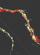
2019 | Freshwater | Technology | Science | Maps & Webmaps
GDE Pulse: Monitoring Groundwater Dependent Ecosystems with Satellites
Kirk Klausmeyer, Falk Schuetzenmeister, Nathaniel Rindlaub, Tanushree Biswas, Melissa M. Rohde, Jeanette Howard
94,333 unique ecosystems depend on groundwater in California. GDE Pulse lets you see how they have changed over the last 30 years. Groundwater managers and environmental stakeholders often lack…
2017 | Terrestrial | Technology | Science | Publications & Reports
Testing a Remote Sensing-Based Interactive System for Monitoring Grazed Conservation Lands
Lawrence D. Ford, H. Scott Butterfield, Pete A. Van Hoorn, Kasey B. Allen, Ethan Inlander, Carrie Schloss, Falk Schuetzenmeister, Miriam Tsalyuk
The Nature Conservancy developed RDMapper, a web-based tool that uses satellite-based productivity estimates, rainfall records, and compliance history to identify easement properties at risk of being…