Charlotte Stanley
Spatial Data Analyst
Technology
[email protected]
As a Spatial Data Analyst, Charlotte performs spatial and data analysis for TNC California’s land, oceans, waters, and cities programs. In her first two years with TNC, Charlotte has analyzed the connection between groundwater and surface water in the Central Valley, mapped the suitability of nature-based climate solutions statewide, and developed a web tool that explores how variation in urban tree canopy relates to income inequality in major U.S. cities. Charlotte also leads GIS for the Disaster Resilience program, developing maps and analysis to guide the coastal and wildfire resilience strategies.
Prior to the Conservancy, Charlotte worked for Urban Green Council and the New York City Department of Sanitation’s Bureau of Recycling & Sustainability. Charlotte holds a Masters in Environmental Management from the Yale School of the Environment, where she focused on spatial analysis and land conservation, and a B.S. in Environmental Science from UCLA.
What Charlotte is working on now:
I am currently developing a greenprint for Southern California, an online mapping tool that will allow planners and agencies to integrate conservation and natural resources into their decision-making.
Select products
2026 | Terrestrial | Planning | Science | Publications & Reports
California’s 30 x 30 Initiative at its Midpoint: A Biodiversity Assessment Snapshot of the State’s Conservation Areas
Jeanette Howard, Carrie Schloss , Rachael Olliff Yang, Alicia Canales, Charlotte K. Stanley, Megan Webb, David Ackerly, Carl Boettiger, Cassie Buhler, Steven Monfort, Gary Bucciarelli, Rachel Meyer, Ariel Levi Simons, Jun Bando, Liz Chamberlin, Sam Veloz, Cole Dickison, Avery Hill, Rebecca Johnson, Ryan Hill, Amanda Kochanek, Dan Rademacher, Lisa Micheli, Kristeen Penrod, Giovanni Rapacciuolo, Nathaniel Roth, Dena Spatz, Daniel Gluesenkamp, and collaborators
2025 marked midpoint in the decade for achieving California’s 30×30 objectives (i.e. the commitment to conserve 30% of California’s lands and coastal waters by the year 2030)…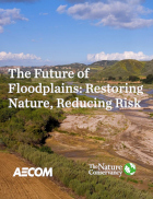
2026 | Freshwater | Terrestrial | Planning | Technology | Science | Publications & Reports
The Future of Floodplains: Restoring Nature, Reducing Risk
Aryeh Cohen, Victoria Salgado, J.D. McLandrich, Nicholas Wellbrock, Deborah Glaser, Piper Wallingford, Charlotte Stanley
Across California, climate change is making floods more frequent, intense, and damaging. Powerful atmospheric rivers now deliver enormous volumes of rainfall over short periods, overwhelming rivers,…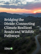
2026 | Terrestrial | Planning | Science | Publications & Reports
Bridging the Divide: Connecting Climate Resilient Roads and Wildlife Pathways
Cara Lacey, Trish Smith, Charlotte Stanley, Deborah Glaser, Piper Wallingford
California stands at a pivotal crossroads where climate resilience, infrastructure modernization, and habitat connectivity must be advanced together. Bridging the Divide offers a roadmap for how…
2023 | Terrestrial | Marine | Technology | Science | Publications & Reports
Minimizing conservation impacts of net zero energy systems in the western United States
Grace C. Wu, Ryan A. Jones, Emily Leslie, James H. Williams, Andrew Pascale, Erica Brand, Sophie Parker, Brian Cohen, Joseph Fargione, Julia Souder, Maya Batres, Mary G. Gleason, Michael H. Schindel, Charlotte K. Stanley
This paper presents the results of the Power of Place-West project. The authors combined energy modeling with ecosystem and wildlife habitat data to determine the costs and impacts associated with…
2022 | Marine | Technology | Science | Publications & Reports
Using unoccupied aerial vehicles to map and monitor changes in emergent kelp canopy after an ecological regime shift
Vienna R. Saccomanno, Tom Bell, Camille Pawlak, Charlotte K. Stanley, Katherine C. Cavanaugh, Rietta Hohman, Kirk R. Klausmeyer, Kyle Cavanaugh, Abby Nickels, Waz Hewerdine, Corey Garza, Gary Fleener, Mary Gleason
Kelp forests are complex underwater habitats that provide valuable services for both people and nature. Despite their importance, increasingly severe stressors have resulted in declines in kelp…
2022 | Terrestrial | Planning | Science | Maps & Webmaps
Conserving a Global Biodiversity Hotspot, 30x30: A Path to a Resilient Future
In October 2020, Governor Newsom signed an executive order committing to protect 30% of California by 2030. This could put California on a trajectory to stem the biodiversity crisis. But, where this…
2021 | Freshwater | Terrestrial | Marine | Planning | Science | Video
StoryMap: Restoring coastal wetlands for climate resilience: A case study at Naval Base Ventura County Point Mugu
Charlotte Stanley, Alyssa Mann, Walter Heady
The United States operates thousands of military installations in the U.S. and worldwide, worth about $1.2 trillion. These facilities are where personnel train and test weaponry, with…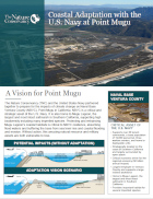
2021 | Freshwater | Terrestrial | Marine | Planning | Science | Publications & Reports
Coastal Adaptation with the U.S. Navy at Point Mugu
Alyssa Mann, Walter Heady, Charlotte Stanley
TNC and the United States Navy partnered together to prepare for the impacts of climate change on Naval Base Ventura County (NBVC), Point Mugu in California. NBVC is a critical and strategic asset of…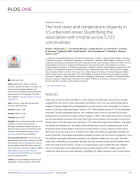
2021 | Terrestrial | Technology | Science | Publications & Reports
The tree cover and temperature disparity in US urbanized areas: Quantifying the association with income across 5,723 communities
Robert I. McDonald, Tanushree Biswas, Cedilla Sachar, Ian Housman, Timothy M. Boucher, Deborah Balk, David Nowak, Erica Spotswood, Charlotte K. Stanley, Stefan Leyk
Urban tree cover provides benefits to human health and well-being, but it is often inequitably distributed. In this study, researchers Google Earth Engine (GEE) and an automated machine learning…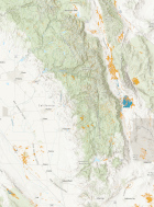
2021 | Freshwater | Terrestrial | Planning | Technology | Science | Data
Natural Communities Commonly Associated with Groundwater Version 2.0 (NCCAG 2.0)
Kirk Klausmeyer, Jeanette Howard, Melissa Rohde, Charlotte Stanley
The first step to sustainably manage groundwater dependent ecosystems (GDEs) is to identify where they are. The Nature Conservancy developed a statewide spatial database that provides locations of…2021 | Freshwater | Planning | Maps & Webmaps
ICONS: Interconnected Surface Water in the Central Valley
This dataset categorizes the rivers and streams in the Central Valley on the likelihood that they are interconnected surface water (ISW) -- surface water hydraulically connected to groundwater. The…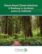
2020 | Freshwater | Terrestrial | Marine | Planning | Technology | Science | Publications & Reports
Nature-Based Climate Solutions: A Roadmap to Accelerate Action in California
Sydney J. Chamberlin, Michelle Passero, Ashley Conrad-Saydah, Tanushree Biswas, Charlotte K. Stanley
California’s natural and working lands – its forests, grasslands, wetlands, farmlands, rangeland, and urban green spaces – provide Californians with numerous environmental, social,…