Megan Webb
Lead Mapping & Design Analyst
Technology
[email protected]
In The Nature Conservancy’s California Chapter, Megan leads the design and development of high visibility maps, graphics, and other data visualizations for a variety of media, provides geospatial support to real estate planning, and manages core spatial data to track real estate investments. She has over 15 years of experience working in the fields of cartography, geographic information science, ecological restoration and conservation science. Her mapping and design work facilitates the communication and understanding of complex spatial information in order to raise awareness of and advance the Conservancy’s work in California.
Prior to the Conservancy, Megan worked at the Conservation Biology Institute, the Cheadle Center for Biodiversity and Ecological Restoration (CCBER) at the University of California, Santa Barbara, and Magellan Geographix/Maps.com. Megan holds a B.A. in Geography from University of California, Santa Barbara and has completed postgraduate coursework in geographic information science at Oregon State University.
Select products
2026 | Terrestrial | Planning | Science | Publications & Reports
California’s 30 x 30 Initiative at its Midpoint: A Biodiversity Assessment Snapshot of the State’s Conservation Areas
Jeanette Howard, Carrie Schloss , Rachael Olliff Yang, Alicia Canales, Charlotte K. Stanley, Megan Webb, David Ackerly, Carl Boettiger, Cassie Buhler, Steven Monfort, Gary Bucciarelli, Rachel Meyer, Ariel Levi Simons, Jun Bando, Liz Chamberlin, Sam Veloz, Cole Dickison, Avery Hill, Rebecca Johnson, Ryan Hill, Amanda Kochanek, Dan Rademacher, Lisa Micheli, Kristeen Penrod, Giovanni Rapacciuolo, Nathaniel Roth, Dena Spatz, Daniel Gluesenkamp, and collaborators
2025 marked midpoint in the decade for achieving California’s 30×30 objectives (i.e. the commitment to conserve 30% of California’s lands and coastal waters by the year 2030)…
2022 | Terrestrial | Planning | Science | Maps & Webmaps
Conserving a Global Biodiversity Hotspot, 30x30: A Path to a Resilient Future
In October 2020, Governor Newsom signed an executive order committing to protect 30% of California by 2030. This could put California on a trajectory to stem the biodiversity crisis. But, where this…
2020 | Freshwater | Marine | Science | Microsite
State of Salmon in California
Chinook, coho and steelhead were once tremendously abundant in most of California’s major rivers and streams. As recently as the 1960s, salmon and steelhead were so plentiful in streams that…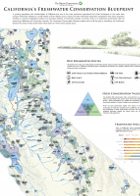
2015 | Freshwater | Planning | Maps & Webmaps
California’s Freshwater Conservation Blueprint map
The transformation of California into one of the most productive agricultural and urban landscapes in the world and a growing population have put unprecedented pressure on freshwater habitats,…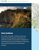
2015 | Terrestrial | Maps & Webmaps
Conservation Legacy in Marin County, California
Katie Andrews, Megan Webb, Robin Cox
This interactive webmap takes a multimedia approach to showcase the Conservancy’s conservation legacy in Marin County, California. Eleven achievements are profiled with photographs and…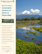
2014 | Freshwater | Maps & Webmaps
Hope Runs Deep: Conservation Solutions for Salmon in Shasta Valley
Using maps, images, and video, this interactive StoryMap illustrates how The Nature Conservancy works with partners in Shasta Valley, California to find conservation solutions that work for…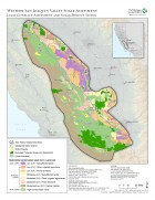
2013 | Terrestrial | Planning | Data
Western San Joaquin Valley Least Conflict Solar Energy Assessment data
Butterfield, H.S., D. Cameron, E. Brand, M. Webb, E. Forsburg, M. Kramer, E. O’Donoghue, L. Crane
The Western San Joaquin Valley Least Conflict Solar Energy Assessment characterizes the land use constraints and opportunities associated with siting solar energy facilities in the Western San Joaquin…
2013 | Terrestrial | Planning | Publications & Reports
Western San Joaquin Valley Least Conflict Solar Energy Assessment
Butterfield, H.S., D. Cameron, E. Brand, M. Webb, E. Forsburg, M. Kramer, E. O’Donoghue, L. Crane
A Conservancy analysis of the western Mojave Desert identified where human activities had degraded the conservation value of lands making them potentially low impact locations for development of solar…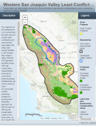
2013 | Terrestrial | Planning | Maps & Webmaps
Western San Joaquin Valley Least Conflict Solar Energy Assessment webmap
This webmap is a product of The Nature Conservancy’s 2013 Western San Joaquin Valley (WSJV) Least Conflict Solar Energy Assessment which characterizes the land use and conservation constraints…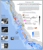
2012 | Marine | Planning | Science | Maps & Webmaps
California Coastal and Marine Program: Protecting Fish Stocks and Livelihoods
Since 2007, The Nature Conservancy has pioneered a first-of-its-kind fishery reform approach that aligns communities, the fishing industry, and conservation interests to drive strategic changes in…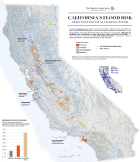
2012 | Freshwater | Maps & Webmaps
California's Flood Risk: Green Solutions for an Uncertain Future
Almost 9 million acres of California are at risk from flooding. These flood zones cover 16% of the state’s urban and suburban development, and 36% of the state’s land dedicated to…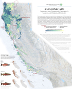
2011 | Freshwater | Marine | Planning | Maps & Webmaps
SalmonScape map
The Conservancy's SalmonScape is an analysis and map that analyzed and ranked the watersheds that support or contribute to salmon habitat in California based on where conservation efforts…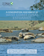
2011 | Freshwater | Marine | Planning | Publications & Reports
Conservation Assessment of U.S. West Coast Estuaries
Mary Gleason, Sarah Newkirk, Matt Merrifield, Jeanette Howard, Robin Cox, Megan Webb, Jennifer Koepcke, Brian Stranko, Bethany Taylor, Mike Beck, Roger Fuller, Dick VanderSchaaf, Jena Carter
While significant progress has been made over the past few decades in improving estuarine water quality, restoring wetland habitats, and incorporating estuarine habitats into managed areas, estuarine…